Through MapMedia, MaxSea TimeZero Navigator ensures the most complete offer in vector charts thanks to privileged agreements with the best electronic chart data providers such as Navionics.
Geonav by Navionics, the first electronic chart device
Pioneer in GPS systems, Navionics launched the very first electronic chart device in the world in 1984, called the Geonav. It quickly became one of the leader in marine cartography, electronic charting and navigation data. Its constant quest for technological innovations has turned Navionics into a reference for data quality and wide electronic chart coverage, very appreciated by sailors and marine professionals all over the world.
Navionics electronic charts can seamlessly cover large areas and allow to zoom down to a resolution of 1 meter (3ft), featuring:
• Tides & Currents
• Port plans
• User-selectable safety depth contour
• Marine services with phone numbers
• Navigation aids with XPlain
• Marsh areas
Navionics provides very comprehensive and frequently updated salt waters, lakes, rivers and marine data, and has achieved remarkable improvements in its latest releases.
Navionics Mega Wide charts now available
Navionics expands its electronic chart offer with the release of several Mega Wide charts:
Africa & Middle East MWVNAF30XGMAP5.1
NEW Africa and Middle East Navionics vector mega wide chart (MWVNAF30XGMAP5.1)
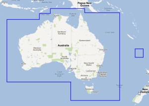
Australia MWVNAU32XGMAP5.1
NEW Australia Navionics vector mega wide chart (MWVNAU32XGMAP5.1)
South China Sea, Korea, Japan MWVNAS35XGMAP5.1
NEW South China Sea, Korea, Japan Navionics vector chart (MWVNAS35XGMAP5.1)
Enhanced quality of marine data
Navionics has collected a wide range of marine depth data through echo soundings in various areas, which profoundly increased the quality of its marine cartography.
See 2 screenshots of the Bahamas area from Navionics and another electronic chart data provider:
Bahamas ocean depth data comparison
Addition of positive values on foreshores
United Kingdom, Ireland and Holland WV28XGMAP1.3
Old and New United Kingdom and Ireland Navionics Vector Charts
The following Navionics Vector charts have been updated and are available as of September 17th, 2012 on our Chart Catalogue:
These updates include the latest charts and NTM provided by our data providers.
Here are some examples of the improvements introduced to Navionics vector charts by zone:
Australia
Old/New Australia – East Navionics vector chart « including The Great Barrier Reef Marine Park Authority data (GBRMPA) (WVNAU62MAP5.1)NEW Australia Navionics vector mega wide chart (MWVNAU32XGMAP5.1)
Mediterranean/Europe Inland
Old/New Mediterranean Sea – West Navionics vector chart (WVNEM32MAP5.1)Mediterranean & Black Sea Navionics vector chart update (MWVNEM43XGMAP5.1)
Africa
Old/New Red Sea – Arabian Gulf Navionics vector chart (WVNME43MAP5.1)NEW Africa & Middle East Navionics vector mega wide chart (MWVNAF30XGMAP5.1)
West Europe/Denmark
Old/New Denmark, Germany, Skagerrak, Sweden West Navionics vector chart (WVNEN15MAP5.1)West Europe Navionics vector chart update (MWVNEW46XGMAP5.1)
The following Navionics Vector charts have been updated and are now available at www.mapmedia.com:
These updates include the latest charts and NTM provided by our data providers.
See some of the modifications that have been introduced to the English Channel, United Kingdom, Ireland, Hamburg and Holland areas:
Old and New United Kingdom and Ireland Navionics Vector ChartsOld and New UK, Ireland & Holland Navionics Vector ChartsOld and New English Channel – Hamburg Navionics Vector Charts
Would you like to see some Old/New chart comparison from a specific area? Just let us know and we’ll publish it as soon as possible.


")


