In 2012, we’ve launched 2 new software version, both for sailing (v1.9.7 and v1.9.8) and professional (v1.2 and v1.2.1) ranges, and redesigned our website.
BBC and Le Figaro media coverage with MaxSea TimeZero screenshots
This year, MaxSea International has proudly supported many skilled sailors, races, projects and navigation-related personalities either as sponsor or as technical supplier, confirming its major role in marine navigation equipment:
The 2012 Nautic Paris Boat Show (Salon Nautique International de Paris) was our must successful event of the year with more than 1000 in-person product demos and the wonderful opportunity to meet and share with our users and enthousiasts.
MaxSea Team at the 2012 Nautic Boat Show
In 2013 we’ll keep you informed about our products, company and many topics in the navigation world. Remember to subscribe to our Newsletter if you want news, special offers & deals and great content!
MaxSea International wishes you a merry christmas and a happy new year!
This is a very special time of the year to tell our users, fans, followers, subscribers, pinners and enthusiasts that we are listening and willing to improve our services and products everyday.
THANK YOU for reading, viewing, enjoying, liking, sharing and commenting our posts, videos, tweets, pins, updates, status, you make us happy!
From December 8th to 16th MaxSea International will be displaying its innovative marine products at the 2012 Nautic Boat Show in Paris.
It’s the most important recreational sailing event in France and a great opportunity for MaxSea to share with its customers and partners and give one-to-one information to the general public.
As always, in-person and group product demos will be held at our stand many times a day, and there will be special prices and deals all along the Boat Show such as the TimeZero Upgrade Offer or our brand new Training + Software Packs.
Although we provide with information about our professional versions (MaxSea TimeZero PLOT & ECS), our activities are mainly focused on our recreational range of products: MaxSea TimeZero Navigator, suitable for all level sailors and motor boaters, and MaxSea TimeZero Explorer, 100% compatible with NavNet3D Furuno marine equipment, who, by the way, shares the stand with MaxSea!
Through MapMedia, MaxSea TimeZero Navigator ensures the most complete offer in vector charts thanks to privileged agreements with the best electronic chart data providers such as Navionics.
Geonav by Navionics, the first electronic chart device
Pioneer in GPS systems, Navionics launched the very first electronic chart device in the world in 1984, called the Geonav. It quickly became one of the leader in marine cartography, electronic charting and navigation data. Its constant quest for technological innovations has turned Navionics into a reference for data quality and wide electronic chart coverage, very appreciated by sailors and marine professionals all over the world.
Navionics electronic charts can seamlessly cover large areas and allow to zoom down to a resolution of 1 meter (3ft), featuring:
• Tides & Currents
• Port plans
• User-selectable safety depth contour
• Marine services with phone numbers
• Navigation aids with XPlain
• Marsh areas
Navionics provides very comprehensive and frequently updated salt waters, lakes, rivers and marine data, and has achieved remarkable improvements in its latest releases.
Navionics Mega Wide charts now available
Navionics expands its electronic chart offer with the release of several Mega Wide charts:
Africa & Middle East MWVNAF30XGMAP5.1
NEW Africa and Middle East Navionics vector mega wide chart (MWVNAF30XGMAP5.1)
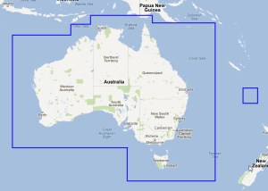
Australia MWVNAU32XGMAP5.1
NEW Australia Navionics vector mega wide chart (MWVNAU32XGMAP5.1)
South China Sea, Korea, Japan MWVNAS35XGMAP5.1
NEW South China Sea, Korea, Japan Navionics vector chart (MWVNAS35XGMAP5.1)
Enhanced quality of marine data
Navionics has collected a wide range of marine depth data through echo soundings in various areas, which profoundly increased the quality of its marine cartography.
See 2 screenshots of the Bahamas area from Navionics and another electronic chart data provider:
Bahamas ocean depth data comparison
Addition of positive values on foreshores
United Kingdom, Ireland and Holland WV28XGMAP1.3
Old and New United Kingdom and Ireland Navionics Vector Charts
The Vendée Globe race, also known as the Everest of the Seas, is the first non-stop solo race around the world without assistance. The 16 ocean skippers (Nov. 19th) will have to sail 25.000 miles around the world and try to arrive first with the help of their own sailing skills and impressive equipment ranging from freeze-dried food to complex solar power plants.
Today, we’re going to focus on the vast array of marine electronic software and hardware and all the means of communication, navigation and localization that are required on board by the Fédération Française de Voile and is listed on the IMOCA’s Equipment Inspection for Offshore Racing:
VHF fixed
Masthead antenna for transmission/reception alternatively on AIS and VHF
Spare VHF Antenna
HD Camera x 3: 2 fixed (1 inside, 1 outside) and 1 waterproof mobile
Radio receiver
Hand-held waterproof VHF Radio with batteries charged and spares, next to the chart table
AIS transceiver, active and software to visualize AIS cables
FleetBroadband 250 or 500 (Inmarsat)
Iridium OpenPort
Other satellite equipment
Boat’s Standard C fitted with GPS card + software for polling and data reporting
Antenna free from any obstacle (60 cm) and at sufficient height (55 cm)
Radar target enhancer (RTE)
Impulse Radar: power >2 kW or Broadband radar
Radome at least 5m above the waterline
GPS
Echo sounder
Speedo/Speed indicator
2 EPIRB – Distress Beacons coded and registered in the boat’s name
PLB in skipper’s name
Individual AIS localization beacon
Paper marine charts for the whole course: scale from 1/5 000 000 to 1/10 000 000
Paper charts or photocopies or screen prints from a marine navigation software or cartography software for landcalls in (click links to access MaxSea’s equivalent charts):
Book or photocopies of book of lights for zones covered on the race.
The 2012 edition of the Vendée Globe, a French race who takes place every 4 years, started on November 10th from les Sables d’Olonne and will last for 3 months.
MaxSea International is one of the official suppliers of this sailing event.
The 2012 Vendée Globe Race starts today and racers are already counting on their marine navigation software to find the best possible route according to weather forecasts and some other important factors.
We’ve launched our Routing Module in order to see what’s the best option at the start of the race and this is what we’ve obtained:
In the image, we can see that at 10am on the 12th, there will be poor wind, which is bad news for the 20 skippers…so we’ve decided to relaunch it using the Alternative Routing feature to see if there could be another more accurate route surrounding that area:
What we’ve got, is a route that goes further in the Ocean, avoiding the Spanish Coast as compared to the previous one:
Here’s a reenactment of this second alternative route for the Vendée Globe racers:
We’ll see which one is taken by the skilled sailors…Good winds for all of them!