Last week, Regional Sales Manager Thibault Hua represented MaxSea at the IceFish exhibition which took place in Reykjavik. IceFish is the must-visit event of the commercial fishing industry. Here he tells us how it went.
MaxSea products were displayed at the stand of Iceland’s Furuno distributor Brimrún. Special emphasis was placed on our PC-radar and fishing-PC sounder solutions with Furuno sensor integration. The new WASSP interface was also very successful because of the increase in productivity and time it represents for bottom mapping tasks.
Brimrún has been the exclusive MaxSea distributor in Iceland for the last 3 years, and is highly-knowlegable on our software. Their input has always been priceless to the improvement of our products. Brimrún spends time training customers on how to use MaxSea. They have organised several training seminars and more are planned for the future. Get in touch with Brimrún to learn more.
Thibault would like to thank them for their support over the past years and for their welcome during the show.
Joëlle & Janusz Kurbiel are members of the polar navigation expedition group IMERPOL and use MaxSea TimeZero software on board. In July they updated us on their current expedition which is taking them through Newfoundland. Here is the latest news from their travels.
Well, the storms and autumn weather are well and truly here!
Luckily, we were able to complete all our planned observations in the North this season and the results are very promising.
Now it is time to focus our attention on the gallant Vagabond’elle vessel to prepare for the harsh winter. There will be lots of snow and temperatures as low as -25°C north of Newfoundland.
We must repair some damage to the boat, the most important being a leak that we have not yet localised, abnormal engine vibrations, some equipment failures, and especially re-do the paint and varnish work again. All the charms of a wooden boat!
But for now the wind howls in the rigging and we need to wait for a lull…
It gives us great pleasure to share this wonderful adventure.
Catch up on IMERPOL’s other MaxSea blog posts here:
MaxSea distributor Radio Electronic CC is located in Namibia and tells us about a recent installation of the commercial fishing software MaxSea TimeZero PLOT on one of Namibia’s Fisheries Patrol vessels, AK Mungunda.
Walvis Bay, Namibia
The vessel, “Anna Kakurukaze Mungunda”, is one of two Namibian Fisheries patrol vessels, based in Walvis Bay, Namibia:
Namibian Fisheries Patrol vessel, the “Anna Kakurukaze Mungunda”
She was built in 2003, is 59m in length and has a gross tonnage of 1413t.
As two of the Namibian Research vessels are already outfitted with MaxSea TimeZero installations, it was a logical choice to have the same type of system installed on this patrol vessel – for ease of sharing user data, such as PBG bathymetric data, among each other.
Last month, MaxSea Inside Sales Representative Irina Kuca, had the opportunity to visit two MaxSea distributors located in Hamburg, Germany: HanseNautic and Furuno Deutschland.
Day 1: Hansenautic
On her first day, Irina visited HanseNautic, a long-time partner of MaxSea. The HanseNautic store is located besides the biggest harbor of Hamburg. During her visit Irina answered the employees’ questions and provided training for MaxSea customers.
The HanseNautic store frontHansenautic employees Jens Rupprecht and Nils NohrThe MaxSea TimeZero installation at HanseNautic
In the evening, Hansenautic employees Jens Rupprecht and Nils Nohr took time to show Irina the Hamburg harbour. Coincidentally, the the 7th largest cruise ship in the world, the Queen Mary 2, was docked there. The day ended with a typical “German” dinner: schnitzel with French fries.
Irina Kuca pictured with the Queen Mary 2 cruise ship
Day 2: Furuno Deutschland
The next day, a meeting with John Dempsey, Ruediger Engel and Claus Frederiksen from Furuno Deutschland was scheduled. Furuno Germany greeted Irina with a nice welcome message, which was placed on the screen at the entrance. John Dempsey introduced her to the whole crew of Furuno Germany.
Irina Kuca with John Dempsey and Kai Thiede
The two day trip to Germany was successful and Irina together with MaxSea are looking forward to work with Hansenautic and Furuno Germany for many years to come.
Last week, MaxSea and ENL (Electronic Navigation Limited) co-hosted a training seminar event in Barcelona. Over 46 distributors and partners attended from 21 different countries around the world in order to learn more about MaxSea TimeZero software and the WASSP multi-beam sounders.
Dates: August 26th – 30th, 2014
Speakers: Iker Pryszo (MaxSea), Phil Seyb and Nick Fogarty (ENL)
2 days of on-board training aboard the MaxSea boat
The Classroom Training
The Group Sales Manager at MaxSea, Frédéric Algalarrondo gave an introductory speech, welcoming all the particpants to Barcelona, and explained the schedule of the week.
Iker Pryszo then spent one day giving a technical training session on TimeZero Coastal Monitoring, a turnkey surveillance system that can be configured for a range of commercial applications, such as for ports, harbors or oil rigs.
On the second day, Iker presented MaxSea TimeZero PLOT, which is designed for commercial fishing and can now be integrated with WASSP multi-beam sounders, resulting in an extremely effective and powerful fishing aid. The MaxSea WASSP Module is required for this software-hardware integration.
The third day of classroom training was a techical training on the WASSP multi-beam sounders, presented by Phil Seyb and Nick Fogarty.
The Welcome Dinner
After the first day of training, all the seminar attendees plus the MaxSea Naval staff enjoyed a dinner together. Some people stayed out later than they should have, but the details of this night are highly confidential and cannot be publicly disclosed…
This was only the beginning…
Onboard Training
The last part of this seminar took place on the MaxSea boat. Attendees were invited to board at the Barcelona marina and see the installation of WASSP multi-beam sounder integrated with MaxSea TimeZero PLOT in action.
Seminar attendeesThe view from the boat!Brice Pryszo, CEO and President of MaxSeaThe MaxSea Naval staff
We would like to thank everyone for coming to the seminar, and it was a pleasure to meet so many distributors and partners and have the opportunity to have an enjoyable and informative week together.
If you would like to learn more about the products featured in this seminar, please use the below contact details:
If you are considering sailing Europe, then Croatia could be the perfect destination. This beautiful coastline off the Mediterranean and the Adriatic Sea offers pristine beauty and more than 1500 islands.
Our contact Romeo Demes from Charter Orvas has given us some insider tips on the nicest areas to sail to in Croatia.
Dubrovnik
Dubrovnik is a UNESCO World Heritage Site. It is home to the Lastovo Archipelago Natural Park and the Island Mljet National Park where you can view exotic flora and fauna. There are several yacht charters where you may rent a boat and sail on your own or you may choose to use the numerous cruise tours offered by different hotels.
Highlights: Dubrovnik is probably the first place that comes to mind when you think of Croatia. This walled Medieval city whose walls have totally stood the test of time is a beautiful coastal town that borders the Adriatic. It is home to quite a number of islands like the Elafiti Islands which make the perfect environment for an exciting sail and excursion. For a feel of some great historical architecture, visit Kornati town located on the Kornati Island where you’ll also find the knight’s game of Moreska is still practiced.
Recommended route: Dubrovnik to Lopud to Saplunar Bay to Pomena to Lastovo to Korcula to Polace and back to Dubrovnik and at each stop, it is best to spend a full day so as to enjoy all that Croatia has to offer.
Image source: Orvas Yachting
Kornati Islands
The Kornati Islands are a cluster of many islands including the Pag, Pasman, Dugi Otok, earning it the name Kornati Archipelago. Its indented coastline together with the perfect wind conditions provide the thrill needed for an exciting sail around these islands.
Highlights: The islands are home to the Plitvice Lakes National Park and the Kornati Islands National Park in case you want to get in touch with nature. The historical towns of Zadar and Sibenik are also nice spots to visit.
Recommended route: Sail through to Biograd then to Bozava Bay, to Telascica Bay then to NP Kornati. From there sail to Zlarin, to Skradin, to Vrgada Island, to Biograd then, back to Kornati. Along the way, enjoy the rich Croatian culture, the beautiful weather, warm beaches, deserted islands and the serenity and calm of the waters.
Island of Vis
Vis, the hidden gem of Croatia is home to some of the most exciting features of the Mediterranean.
Highlights: Head to the Blue Cave also known as the Blue Grotto and the Zelena Spilja, the Green Cave. These are great places to dive and enter, using their below sea-level entrances. The beautiful blue waters of the Adriatic and the beautiful beaches at Vis make an ideal environment for diving, snorkelling, swimming and excursions.
Recommended route: A great route to follow is from Kastela to Maslinica Bay then to Komiza, then to Bisevo, to Islet Budihovac to Stonicica. From here, sail to Hvar, to Stari Grad to Milna and back to Kastela.
Croatia is a sailor’s paradise. Most of it is almost untouched by man. The spectacular coastline, beautiful beaches, peaceful waters and picturesque sights will keep you glued to this country once you visit it.
We would like to thank Romeo Demes from Charter Orvas for writing this article.
We are happy to inform you that version 2.1 of the MaxSea TimeZero professional range MaxSea TimeZero PLOT and ECS has just been released and is available to download now.
Version 2.1 includes a range of innovative new features as well as several corrections. These improvements provide provide commercial fishing vessels and work boats with powerful functions that will make these activities even more efficient. This update is completely free of charge for all existing MaxSea TimeZero ECS and PLOT users!
Here are a few of the main improvements you will find in version 2.1:
New features in MaxSea TimeZero PLOT
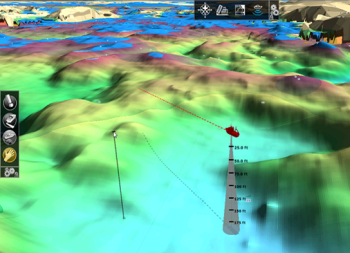
New 3D WorkSpace: can be set to full screen or split screen (2D/3D), improved display options. See image below:
The Bathy Recorder function has been completely redesigned – for even more targeted fishing.
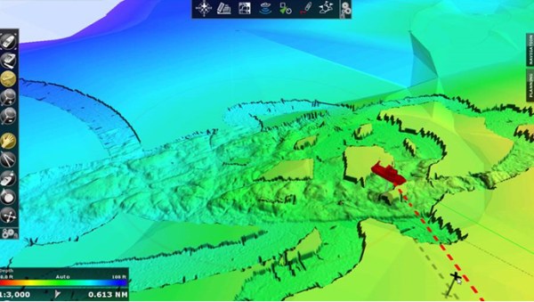
Addition of Manual Contour Lines and new Contour Line Tool. The contour line interval can be adjusted to a fixed step and user can choose a “highlight” contour line depth. See below image:
New features in MaxSea TimeZero ECS and PLOT
Proudman Currents are now available for various zones in Europe and the Arabian Gulf.
Sounder history has been increased to multiple hours. The Furuno Sounder Module is Required for this.
When integrating with a Furuno NavNet 3D or TZtouch MFD, TimeZero can access the NavNet DRS Dual Range capability from a new “Dual Radar” WorkSpace.
Fleet Tracking Position Report: TimeZero now automatically creates the Position Report file that can be sent manually or synchronized among multiple vessels using the file hosting service Dropbox. User can choose the frequency of these reports.
Several other new features have also been added to this update, as well as miscellaneous functions and bug corrections.
Price: The update to version 2.1 is totally free for all current MaxSea TimeZero users.
Download: You can contact your regular MaxSea reseller to download this update. Alternatively, you may log into your MyMaxSea account and use the download link in the ‘Downloads’ tab.
Leon Schulz is a MaxSea partner and is a RYA Yachtmaster Ocean instructor. This week, he tells us about his unforgettable experience, navigating his yacht, the Regina Laska to one of the lochs in Scotland, Loch Scavaig in the Isle of Skye, Scotland.
Arriving at Loch Scavaig brings a feeling of a total immersion in nature. Cautiously approaching the narrow harbour entrance, I like to compare the notes in the Imray Pilot Book “Skye and North West Scotland” with MaxSea navigation charts. Both the Navionics, Jeppesen and raster charts in MaxSea provide similar chart data and are very helpful.
Loch Scavaig, Isle of Skye, Scotland
My observation at the harbour entrance, however, is that the water depth is slightly less than is claimed in all the available books and charts, and so, boaters should expect water depths of about 1-1.5 m more shallow than charts indicate, not only during low tide.
When you arrive at the lagoon, you will be greeted by innumerable seals resting on the soft ground rock or curiously peeping out of the water. So we stare at each other and are enchanted by the contact between humans and animals.
The silence of the mountains lying around is only interrupted by one sound – the noise of a waterfall, where the water seems to spring out of the fog into which bore into the mountains. Angelic water?
Slowly, carefully, and with the support of the Furuno NavNet 3D plotter, integrated with MaxSea TimeZero Explorer, we continue into the lagoon. There is no other boat in the area, not a soul. Even our mobile phone doesn’t have reception – no contact with the outside world. Only a small cabin with closed window shutters in the colors of the Scottish flag testifies to the fact that sometimes people here have to seek shelter when the weather becomes too harsh, as is the reputation of Scotland.
The dramatic scenery is breathtaking and so we put our dingy into the water and row ashore. Trails meander along lakes and high up into the mountains with a beautiful view over half Scotland, if not over half of the world. Time and space seem to merge.
My charter guests who have travelled with me all the way from Canada on my HR 46 Regina Laska boat, are full of happiness.
In the evening another yacht arrives in the area and anchors next to us. An aluminum yacht that looks as if it has come from as far as Greenland, Svalbard or Antarctica.
We happily sleep in this paradise, until we are awakened the next morning by a motor noise: A tour boat from the nearby mainland. And then another one. And later another. There are lots of hikers who have stopped here for a couple of hours, to see the same beauty that we had enjoyed in our loneliness the night before. But would they experience the same as us?
Yes, we think, and enjoy the morning coffee while in the sunlit cockpit.
No heaven can be kept for you alone! “Paradise is a state of mind,” said my charter guest. How true! We recognise that my favorite anchorage is no longer a secret. But as long as we believe it, we could feel unique and special in this world.
With this in mind, we drop anchor and sail instead of continuing to the nearby Talisker distillery.
Leon Schulz’s yacht, the Regina Laska is available for charter. Learn more about his services on the Regina Sailing website.
The following 38 Jeppesen vector chart zones for the Rest of World have been updated and are available as of Thursday, August 7th, 2014.
Download these nautical charts online from our Chart Catalog
Improvements to these Nautical Charts
The chart data in these zones has been updated and improved. Many areas now include additional details, which makes navigating these places simpler and much safer.
Here are some examples of direct comparisons between the last version and new versions of the charts:
What kind of boat propellers do you use? Do you take care of them regularly? MaxSea partners from IMERPOL, Joëlle & Janusz Kurbiel explain the importance of your boat’s propellers. Here, they tell us about their experiences during their polar expeditions:
It can be quite a terrifying experience to navigate a vessel when there is no wind for the sails making all movement entirely dependent on the engine and propeller. However, this situation can often arise. It happened to us several times while navigating around the Poles.
A caged and fixed propeller
Caged vs. non-caged fixed propellers
In the Nordic countries, a kind of protective cage is often built around the propeller which is attached to the hull on small vessels.
Even if this cage effectively protects the propeller against large pieces of ice sliding over it, pieces of debris can still get lodged between the spokes. This could be pieces of wood, ropes, nets or tarpaulins floating in the water or even small pieces of ice. This can be a real pain to remove!
We had protective cages on our vessels Vagabond, Vagabond Vagabond’eux and Exploraglobe. However, for our later vessels Vagabond’eur and Vagabond’elle, we finally opted for a fixed propeller which is unprotected but thicker. These propellers were made especially for us, with an oversized rope cutter.
Strengths of fixed propellers:
They allow the driftwood or ice to escape on its own, and
If the rope cutter is effective against small ropes, it also protects against nets and other coverings
Ice can cause serious damage to your boat propellers
Recently, during the launch of Vagabond’elle, a piece of carpet got twisted around the propeller. We needed to take the boat out of the water and two of us worked for an hour to remove. You’re either lucky or you’re not…
Interested in learning more about IMERPOL? Here are the previous blog posts they have written for MaxSea:


 17 Fourteenth Road, Po Box 670, Walvis Bay, Namibia
 +264 64207483