NOAA Raster and Vector Chart Updates for the USA are Available Now!

These US charts have been updated and are available as of March 17th, 2015 in our Chart Catalogue:

MaxSea NOAA Chart Update List

The following NOAA chart versions are now available:

  • VECTOR – MWVSUSAMAP9.1 NOAA Vector Charts & USACE Inland Charts
US_NOAA_charts_coverage

Updated Information

  • Updated NOAA Vector Charts (S57): This Edition adds 70 new Vector Charts to the library as well as many other chart updates.
  • Updated NOAA Raster Charts: This new edition includes the latest chart updates that can be found on the NOAA paper charts.

Read full information about these chart updates in this PDF file.

Clickforexamples

NOAA charts are totally free of charge and you can download them through our Chart Catalog, to make sure that you’re using the most up-to-date chart data available for US waters.

Watch our new video - 5 Interesting Facts about Nautical Charts

Raster Chart Updates for the Transat, Central America and Caribbean

The following 4 Raster chart zones covering the Transat, Central America and the Caribbean have been updated and are available to download in our Chart Catalogue as of January 29th, 2015:

Raster Chart Promo MaxSea February

Save on These Charts!

We are offering great discounted pricing on each of these newly-updated charts! Check out the promotional prices here!

Improvements

These chart updates include updated information (changes in ports, harbors, buoys etc.) as well as corrections to chart data. It is recommended to update your chart zones regularly in order to have the most up-to-date information for navigation. This is very important for safety on board.

Here are a few examples of the enhancements in these chart zones:

R50 lanzarote

R912 panama

You can find further examples of the changes made to these updates charts in our Facebook or Google+ albums.

Take me to the MaxSea Webstore

Raster Chart Updates for West Europe and the Mediterranean

The following 6 Raster chart zones covering the west of Europe and the Mediterranean have been updated and are available to download in our Chart Catalogue as of December 5th 2014:

raster charts

Improvements

These chart updates include updated information (changes in ports, harbors, buoys etc.) as well as corrections to chart data. It is recommended to update your chart zones regularly in order to have the most up-to-date information for navigation. This is very important for safety on board.

Here are a few examples of the enhancements in these chart zones:

R30 Concarneau

R32 Barcelona

You can find further examples of the changes made to these updates charts in our Facebook or Google+ albums.

Take me to the MaxSea Webstore

The MaxSea-WASSP Seminar in Barcelona

Last week, MaxSea and ENL (Electronic Navigation Limited) co-hosted a training seminar event in Barcelona. Over 46 distributors and partners attended from 21 different countries around the world in order to learn more about MaxSea TimeZero software and the WASSP multi-beam sounders.

Dates: August 26th – 30th, 2014

Speakers: Iker Pryszo (MaxSea), Phil Seyb and Nick Fogarty (ENL)

Programme:

MaxSea-WASSP seminar

The Classroom Training

The Group Sales Manager at MaxSea, Frédéric Algalarrondo gave an introductory speech, welcoming all the particpants to Barcelona, and explained the schedule of the week.

Iker Pryszo then spent one day giving a technical training session on TimeZero Coastal Monitoring, a turnkey surveillance system that can be configured for a range of commercial applications, such as for ports, harbors or oil rigs.

On the second day, Iker presented MaxSea TimeZero PLOT, which is designed for commercial fishing and can now be integrated with WASSP multi-beam sounders, resulting in an extremely effective and powerful fishing aid. The MaxSea WASSP Module is required for this software-hardware integration.

The third day of classroom training was a techical training on the WASSP multi-beam sounders, presented by Phil Seyb and Nick Fogarty.

MaxSea

The Welcome Dinner

After the first day of training, all the seminar attendees plus the MaxSea Naval staff enjoyed a dinner together. Some people stayed out later than they should have, but the details of this night are highly confidential and cannot be publicly disclosed…

MaxSea-WASSP Seminar Dinner
This was only the beginning…

Onboard Training

The last part of this seminar took place on the MaxSea boat. Attendees were invited to board at the Barcelona marina and see the installation of WASSP multi-beam sounder integrated with MaxSea TimeZero PLOT in action.

MaxSea WASSP onboard training
Seminar attendees
The MaxSea WASSP onboard training
The view from the boat!
Brice Pryszo, CEO and President of MaxSea
The MaxSea Naval staff

You can view more photos from the onboard training in this MaxSea Facebook album.

We would like to thank everyone for coming to the seminar, and it was a pleasure to meet so many distributors and partners and have the opportunity to have an enjoyable and informative week together.


If you would like to learn more about the products featured in this seminar, please use the below contact details:

MaxSea TimeZero PLOT: info@maxsea.fr

TimeZero Coastal Monitoring: info@tzcoastalmonitoring.com

WASSP Multi-Beam Sounders: Fill out this contact form


Find a reseller - MaxSea TimeZero PLOT

Release of Version 2.1 of MaxSea TimeZero Professional Range

We are happy to inform you that version 2.1 of the MaxSea TimeZero professional range MaxSea TimeZero PLOT and ECS has just been released and is available to download now.

Version 2.1 includes a range of innovative new features as well as several corrections. These improvements provide provide commercial fishing vessels and work boats with powerful functions that will make these activities even more efficient. This update is completely free of charge for all existing MaxSea TimeZero ECS and PLOT users!


Read a complete description of the improvements in v2.1 of the MaxSea TimeZero professional range


Here are a few of the main improvements you will find in version 2.1:

New features in MaxSea TimeZero PLOT

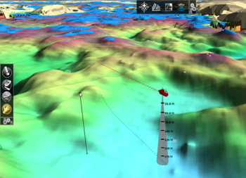
  • New 3D WorkSpace: can be set to full screen or split screen (2D/3D), improved display options. See image below:

New 3D display in v2.1

  • The Bathy Recorder function has been completely redesigned – for even more targeted fishing.
  • Addition of Manual Contour Lines and new Contour Line Tool. The contour line interval can be adjusted to a fixed step and user can choose a “highlight” contour line depth. See below image:
New manual contour lines

New features in MaxSea TimeZero ECS and PLOT

  • Proudman Currents are now available for various zones in Europe and the Arabian Gulf.
  • When integrating with a Furuno NavNet 3D or TZtouch MFD, TimeZero can access the NavNet DRS Dual Range capability from a new “Dual Radar” WorkSpace.
  • Fleet Tracking Position Report: TimeZero now automatically creates the Position Report file that can be sent manually or synchronized among multiple vessels using the file hosting service Dropbox. User can choose the frequency of these reports.

Several other new features have also been added to this update, as well as miscellaneous functions and bug corrections.


Price: The update to version 2.1 is totally free for all current MaxSea TimeZero users.

Download: You can contact your regular MaxSea reseller to download this update. Alternatively, you may log into your MyMaxSea account and use the download link in the ‘Downloads’ tab.

Read full description of v2.1 of MaxSea TimeZero Professional Range

Jeppesen Charts Updated for Rest of World

The following 38 Jeppesen vector chart zones for the Rest of World have been updated and are available as of Thursday, August 7th, 2014. 

New chart updates: Jeppesen Vector charts for Rest of WorldDownload these nautical charts online from our Chart Catalog

Watch our new video - 5 Interesting Facts about Nautical Charts

Improvements to these Nautical Charts

The chart data in these zones has been updated and improved. Many areas now include additional details, which makes navigating these places simpler and much safer.

Here are some examples of direct comparisons between the last version and new versions of the charts:

BAYKAL AND SIBERIAN LAKES – WVJRSM217MAP6.1:

Old/New Lake Ivan

SYDNEY HARBOUR – MWVJAUM007MAP6.1:

Old /New Sydney Harbour

NORTH – WEST AFRICA – WVJAFM210MAP6.1

Old/New Canaries

See more examples of the new chart updates in our Google+ and Facebook albums.

These charts are available to purchase in the MaxSea webstore, by contacting MaxSea sales at info@maxsea.fr or through your local MaxSea reseller.

.

New MaxSea Chart RSS Feed

Important Chart Warning: Caution with Vertical Clearances on some Canada Raster Charts

The Canadian Hydrographic Service (CHS) would like to let you know of that the vertical clearances (bridges, etc…) on charts and equivalent BSB 1313, 1314, 4026, 4275, 2250, 2283-1, 2283-2, 4266, 4201 are inaccurate. Caution.

The MapMedia mm3d Charts concerned are:

Canada Chart – MWRMNA80MAP (only East Coast and Great Lakes)

Canada Nautical Chart - MWRMNA80MAP

Great Lakes – West Chart – WRMNA900MAP

Great Lakes - West Nautical Chart - WRMNA900MAP

Great Lakes – East Chart – WRMNA901MAP

Great Lakes - East Nautical Chart - WRMNA901MAP

Canada – St Lawrence River Chart – WRMNA902MAP

Canada - St Lawrence River Nautical Chart - WRMNA902MAP

Canada – Newfoundland Chart – WRMNA903MAP

Canada - Newfoundland Nautical Chart - WRMNA903MAP

Feel free to contact us if you need any further information.

New MaxSea Chart RSS Feed

Jeppesen Chart Updates for Europe

The following 24 Jeppesen vector chart zones for Europe have been updated and are available as of Thursday, July 17th, 2014. 

Europe Jeppesen Vector Chart UpdateDownload these nautical charts online from our Chart Catalog

New MaxSea Chart RSS Feed

Nautical Charts Enhancements

The chart data in these zones has been updated, and many areas now include additional details, which makes for the safest navigation possible.

Here are some examples of direct comparisons between the last version and new versions of the charts:

NORTH-WEST EUROPEAN COASTS – WVJEWM227MAP6.1 NORTH-WEST EUROPEAN COASTS WEST EUROPEAN COASTS AND WEST MEDITERRANEAN – MWVJEWM010MAP6.1 WEST EUROPEAN COASTS AND WEST MED. EUROPEAN INLAND WATERS – MWVJENM018MAP6.1 EUROPEAN INLAND WATERS

See more examples of the new chart updates in our Google+ and Facebook albums.

These charts are available to purchase in the MaxSea webstore, by contacting MaxSea sales at info@maxsea.fr or through your local MaxSea reseller.

Watch our new video - 5 Interesting Facts about Nautical Charts

Jeppesen Chart Updates for North and South America

The following 19 Jeppesen vector chart zones for various parts of North and South America have been updated and are available as of Monday, June 16th, 2014. 

Download these nautical charts online from our Chart Catalog:

Updated navigation chart list

To visualise the coverage of each chart region, simply replace “CHARTREFERENCE” with the chart reference name at the end of the following link:
maxsea.com/products/charts?zonename=CHARTREFERENCE

Enhancements

The chart data in these zones has been updated, and many areas now include additional details, which makes for the safest navigation possible.

Here are some examples of direct comparisons between the last version and new versions of the charts:

Old-New_WVJNAM24_LosCabos2013
Old/new chart example: Los Cabos New chart reference: WVJNAM024MAP6.1
Old-New_WVJNAM26_GreatLakesErie1_2013
Old/new chart example: Great Lakes – Erie Lake New chart reference: WVJNAM026MAP6.1
Old-New_WVJNAM26_GreatLakesErie2013
Old/new chart example: Great Lakes – Erie Lake New chart reference: WVJNAM026MAP6.1
Old-New_WVJNAM26_StLaurent2013
Old/new chart example: Saint Laurent New chart reference: WVJNAM026MAP6.1

See more examples of the new chart updates in our Google+ and Facebook albums.

These charts are available to purchase in the MaxSea webstore,  by contacting MaxSea sales at info@maxsea.fr or through your local MaxSea reseller. Find a reseller here.


5 Tips for Choosing the Best Nautical Chart

Team Ashram Qualifies for World Marlin Championships in Costa Rica!

MaxSea is proud to be a partner of The Ashram Fishing Team. This Australian-based team recently participated in the “Seasport Charters Marlin Cup,” using MaxSea TimeZero PLOT on board. Here is their account of how the tournament went.

The team is made up of Sangeeta Menon, Andy Ziepe, Mark Jarrett and Rhyss Whittred. The Seasport Charters Marlin Cup was hosted by the Perth Game Fishing Club in Jurien Bay, and ran from February 20-23rd.

Jurien Bay is approx. 400km north of Team Ashram’s home port and boasts some excellent game fishing species. The winner of this tournament receives an invite to compete in the Offshore World Championships in Costa Rica for 2015.

Rhyss Whittred gives us his account of the tournament:

Team Ashram's boat“For our team this was the first major tournament we had competed in since I purchased my Wellcraft 270 and revamped the electronics to include Maxsea TimeZero PLOT and Furuno’s latest technology. I can’t say how keen we were to compete and in fact one of the teams there had the reigning world champion angler on board Valkoista (Craig White).

It was a 3 day tournament with your 2 best days fishing score counting towards overall championship points. The night before the tournament commenced I downloaded the latest Maxsea weather file and carefully worked out our fishing plan in line with sea surface temp, currents and plankton.

We headed out and had a cracker of a day. The Maxsea oceanic data was spot on and my team was fantastic with their art of angling and we managed Southern Blue Fin, Striped and Yellowfin Tuna to give us some great points of 2,850 points and our nearest competitors were on 375 points.

Saturday dawned and I planned to go to the same area north where we had done so well Team Ashramthe day before. Alas, the water temperature was down 2 degrees, with no bait and no birds. We could hear others on the radio with great fishing results. Unfortunately I had left my mobile phone at the hotel and couldn’t download a current weather file. We were now at a complete low and did not turn a reel for the day.

The next morning I was up very early and downloaded the weather file and made a plan of attack. In fact the good water and temperature breaks we had 2 days before where now 40kms south of Jurien and we needed to get among it. With the early start we got down there in time for lines in at 6am and once again we tagged our limit of tuna and returned to port.

The scoring by other teams was very good and it was an absolute pleasure to have revealed that the Ashram Team picked up Champion Boat, Champion Female Angler, Runner Up Male Angler and Champion Tag and Release.

So my friends at Maxsea, I thank you all for your cutting edge technology and how it all worked in so well with my Furuno equipment and helping us to win this tournament.”

– Rhyss Whittred

Thanks Rhys! And best of luck for the World Marlin Championships in Costa Rica!

.

.
Plot CTA